Google Earth に新 AI 機能、衛星画像の捏造が可能に
本文の状態
日本語全文を表示中
詳細モードで約3分の本文を読めます。
同じ出来事の情報源
この情報源を基点に整理
404 Media
Google Earth のウェブ版に新機能を追加し、ユーザーが特定の場所を指定してプロンプトを入力するだけで、ドローン攻撃や核施設など現実とは異なる衛星画像を容易に作成できるようになった。
AI深層分析を開く2026年8月1日 01:29
AI深層分析
キーポイント
虚構画像生成機能の実装
Google Earth のウェブ版に新機能を追加し、ユーザーが特定の場所を指定してプロンプトを入力するだけで、ドローン攻撃や核施設など現実とは異なる衛星画像を容易に作成できるようになった。
OSINT 分析への悪影響
通常は紛争や災害の監視に有用なツールである Google Earth が、誤情報(disinformation)を広めるための手段として悪用されるリスクが顕在化し、検証作業を困難にするとの懸念が出ている。
Google の対策と限界
同社は生成された画像に SynthID デジタル透かしを埋め込み、Gemini アプリや検索レンズによる AI 生成判定機能を案内しているが、悪意ある利用者が検証を行わない可能性への対応は不十分との指摘がある。
技術基盤と実証事例
この機能は Google の Nano Banana モデルによって駆動されており、テストではロサンゼルスのホームレスキャンプやアムステルダムの事故現場など、現実の風景に根拠のない要素を付加する事例が確認された。
検知ツールの回避が可能
Googleによって改ざんされた画像を検出するツールを使っていても、それを無効化する方法が存在する。
重要な引用
"It's harrowing and horrific, and it will make verification work much more difficult."
"We take misinformation seriously – every image created with Nano Banana in Google Earth includes the SynthID digital watermark..."
"Tonight I typed just one sentence into Google Earth and put refugees near the Mexican border. Then I planted a nuclear plant in Iran."
"Even if you can use detection tools to determine that an image was altered by Google, there are ways to override those indicators, no matter what people tell you. This is BAD."
編集コメントを表示
編集コメント
画像生成 AI の進歩は、事実と虚構の境界を曖昧にする新たな課題を提示している。技術的な検知機能の導入は第一歩だが、情報の真偽を見極める人間の判断力がこれまで以上に求められる時代となった。
Source Article
元記事を日本語で読む
本文に関係しない購読案内、埋め込み通知、サイト内プロモーションは除いています。
木曜、Google は Google Earth に新しい AI 機能を追加した。これにより誰でも、特定の場所にドローン攻撃があったように見せかけたり、イランに原子力発電所を出現させたりといった、誤解を招くあるいは明らかに不正確な衛星画像を捏造できるようになった。
通常、Google Earth はオープンソース・インテリジェンス(OSINT)分析家が関心のある地域をデジタルで監視し、紛争や災害発生時などにその変化を追跡するための極めて有用なツールだ。しかし今では、このプラットフォームは誤情報拡散のための道具としても容易に利用可能になってしまった。
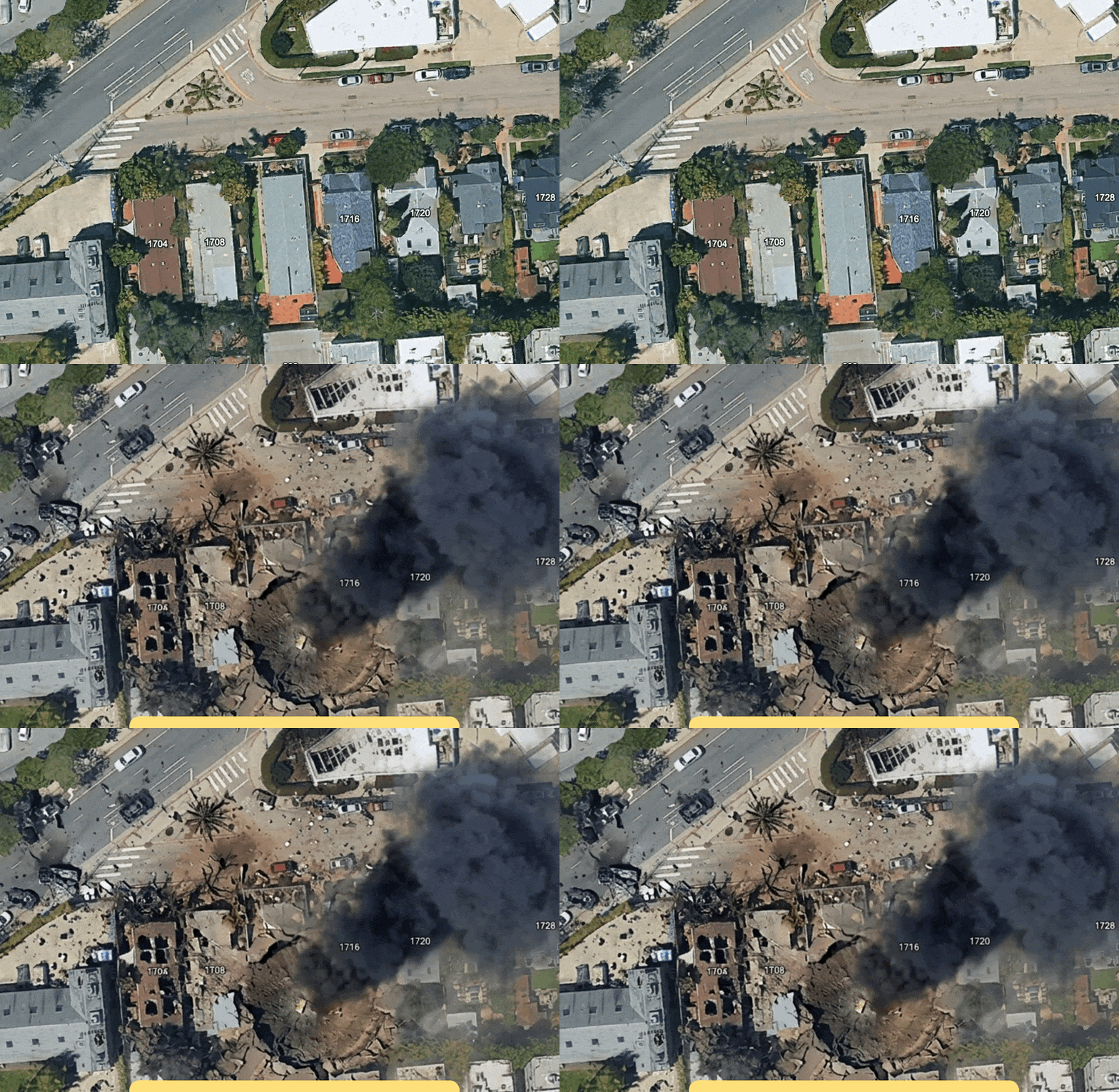
404 Media のテストでは、田舎の地域に高層ビルを追加したり、ホームレス問題が政治的な争点となっているロサンゼルスの一角に「ホームレスのキャンプ」を出現させたり、ロサンゼルスのある場所に「爆発とクレーター」を描き加えたりすることができた。
「今夜、私は Google Earth にたった一つの文を入力しただけだ。メキシコ国境付近に難民を配置し、イランに原子力発電所を設置した。さらにアムステルダムの街路で致命的な墜落事故を起こさせた。これらすべては、Google 自身の衛星画像の上に重ねられている。一体 Google は何をしようとしているのか?」と OSINT 研究者の Hank Van Ess は木曜日のブログ記事で記している。
Google Earth のウェブ版に新たに追加されたボタンを使えば、ユーザーは任意の場所の上にカーソルを合わせた状態でプロンプトを入力し、その場所に新しい画像を作成できます。この機能は Google の声明によると、同社の Nano Banana モデルによって駆動されています。
「職場の住所を入力して『ここがドローン攻撃を受けたように見せる』と指示すれば、ウクライナやロシア、中東など戦争で荒廃した地域で見られるような、非常に現実に近い証拠となる画像が生成されます」と、別の OSINT 専門家であるベン・ヘーブルは LinkedIn の投稿で述べています。
もちろん、これは Google Earth のスクリーンショットが地球上の実際の風景を正確に反映していることを保証するものにはなりません。ヘーブル氏はさらに、「これは恐ろしく、悲惨な事態であり、検証作業を大幅に困難にする」と付け加えています。
コメントを求められた Google は 404 Media に対し、同社が木曜日に投稿したツイートを紹介しました。「私たちは誤情報に対して真剣に取り組んでいます。Google Earth で Nano Banana を使って作成されたすべての画像には SynthID デジタル透かしが含まれており、画像の真偽に不安がある場合は Gemini アプリや検索の Lens を使用して、その画像が AI 生成かどうかを確認できます。また、有害なトピックに関する画像作成を防止しており、保護策は継続的に更新されています」と記載されています。
もちろん、画像が本物かどうかを自分で確認する手間を惜しむ人は大勢いるという明白な事実はこの議論では無視されています。誤情報を拡散する人々も、最終的にばれようが気にしません。彼らは誰かが指摘する前に、特定の議論に対して瞬く間に甚大な被害を与えることができるのです。
ハイブラ氏はさらに、「Google によって画像が改変されたことを検出ツールで特定できたとしても、それを無効化する手段はいくらでもあります。どんなに言われようと、これは危険なことです。」と述べています。
原文を表示
 imageOn Thursday, Google introduced a new AI feature into Google Earth which lets anyone fabricate all sorts of misleading or straight up inaccurate satellite imagery, from making it look like a specific place has suffered a drone strike to manifesting a nuclear plant in Iran.
Usually, Google Earth is an exceptionally useful tool for open source intelligence (OSINT) analysts to digitally monitor areas of interest and see how they change over time, say, during a conflict or disaster. Now, Google Earth can easily be used as a tool for disinformation.
In 404 Media’s tests, we were able to add skyscrapers to a rural area, added a “homeless encampment” to a part of Los Angeles where homelessness has become a major political issue, and were able to add a “bomb blast and crater” to an area of Los Angeles.
“Tonight I typed just one sentence into Google Earth and put refugees near the Mexican border. Then I planted a nuclear plant in Iran. Then I put a fatal crash on a street in Amsterdam. Google’s own satellite imagery underneath all three. What on earth is Google doing?” Hank Van Ess, an OSINT researcher, wrote in a blog post on Thursday.
The button now available in the web version of Google Earth lets a user type in a prompt while hovering over their desired location to create something new there. It is powered by Google’s Nano Banana model, according to a Google statement.
“If you type the address of your workplace and then prompt it to ‘make it look like a drone attack happened here,’ it will create a damning image that looks very close to what we’ve seen in Ukraine, Russia, the Middle East, and other war-torn conflict zones,” Ben Heubl, another OSINT professional, wrote in a LinkedIn post.
Obviously, this isn’t great for ensuring that screenshots from Google Earth are showing what anywhere on the planet actually looks like in reality. “It’s harrowing and horrific, and it will make verification work much more difficult, Heubl added.
Asked for comment, Google pointed 404 Media to a tweet the company posted on Thursday. “We take misinformation seriously – every image created with Nano Banana in Google Earth includes the SynthID digital watermark, so if someone is unsure about an image, they can ask the Gemini app or use Lens in Search to see if the image was AI-generated. In addition, we prevent image creation on harmful topics and are continually updating our protections,” it read.
This of course ignores the very obvious fact that plenty of people do not bother to verify themselves if an image is real or not. People spreading misinformation also often don’t care about eventually getting caught; they can cause a massive amount of damage to a certain conversation very quickly before anyone calls them out for their bullshit.
Heubl added, “Even if you can use detection tools to determine that an image was altered by Google, there are ways to override those indicators, no matter what people tell you. This is BAD.”
関連記事
今日のまとめ
AIデイリーブリーフで今日の重要ニュースをまとめ読み