Google、空のディープフェイク懸念から人工衛星画像生成を一時停止
本文の状態
日本語全文を表示中
詳細モードで約6分の本文を読めます。
同じ出来事の情報源
この情報源を基点に整理
NPR Technology AI
Google は衛星画像生成AIの安全性を懸念し、深層偽造(ディープフェイク)による空からの誤認や悪用を防ぐため、同サービスの提供を一時的に停止した。
AI深層分析を開く2026年8月4日 16:30
AI深層分析
キーポイント
サービスの一時的停止決定
Google は衛星画像生成AIの機能について、安全性への懸念から一時的な停止措置を講じたことを発表した。
深層偽造技術のリスク認識
空からの画像がディープフェイクとして悪用される可能性や、誤認を招く恐れが同社の判断要因となった。
安全性確保のための措置
技術的な悪用を防ぎ、信頼性を維持するために、一時的に機能を停止して再検討を行う方針を示した。
AI生成画像による誤情報の拡散リスク
ペルシャ湾の戦略的石油ターミナルがあるイランのカルグ島で発生した火災を装ったAI生成画像がSNS上で広まり、軍事的緊張の高まりに利用された。
Googleによる衛星画像提供の一時停止
同様の偽造画像が世界中で拡散する恐れがあるとして、GoogleはAI技術を用いた衛星画像の生成機能を一時停止した。
重要な引用
Google pauses AI satellite images, after fears of deepfakes in the sky
"An AI-generated image showing multiple fires on and near Kharg Island, an Iranian island in the Persian Gulf that is home to a strategic oil terminal."
"However we've also seen people sharing screenshots of generated imagery that appear to violate our policies. So we're rolling back this feature in Google Earth while we work on implementing stronger guardrails."
"I tried refugees at the Mexican border, a nuclear plant in Iran, a crash in Amsterdam, a hospital with a bomb crater in Gaza. Nothing was refused."
編集コメントを表示
編集コメント
生成AIの応用範囲が拡大する中、Google が安全性を最優先してサービス停止を選んだ事例は注目される。同社の判断は、技術の普及速度とリスク管理のバランスをどう取るかという業界全体の課題を示唆している。
Source Article
元記事を日本語で読む
本文に関係しない購読案内、埋め込み通知、サイト内プロモーションは除いています。
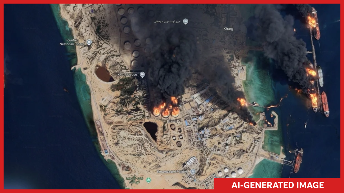
ペルシャ湾に位置するイランの戦略的な石油ターミナルがあるカルグ島とその周辺で複数の火災が発生している様子を示す AI 生成画像。
**
NPR が生成および注釈付け
**
キャプションを隠す
**
キャプションの切り替え**
NPR が生成および注釈付け
Google は、Google Earth プラットフォーム上でボタンをクリックするだけで AI 生成衛星画像を作成できる新機能を公開した翌日、このツールの削除を発表しました。
「地理空間のプロフェッショナルが、この機能を実用的な目的のために活用している様子を確認しています」と Google は X(旧 Twitter)での声明で述べています。「しかし一方で、当社のポリシーに違反する可能性のある生成画像のスクリーンショットが共有されていることも把握しました。そのため、より強力なガードレールを実装するまでの間、Google Earth におけるこの機能を一旦停止します。」
木曜日の新機能発表時、同社はこの機能がユーザーの想像力を活用するよう設計されたものだと説明しました。Google Earth のウェブ版で場所をズームインし、「画像作成」をタップして、見たいものを何でも入力すればよいと、プロダクトマネージャーのブライアン・ホロウィッツ氏は述べています。
しかし、世界中のアクセス困難な地域での速報や虐行を検証するために Google の画像に依存する専門家やアナリストにとって、ボタン一つで偽衛星画像を生成できる可能性は恐怖そのものでした。
「メキシコ国境の難民、イランの原子力発電所、アムステルダムの墜落事故、ガザの病院に爆撃跡がある様子……いずれも拒否されませんでした」と、このツールの潜在的な被害について最初に指摘したオープンソース調査員のヘンク・ファン・エス氏は、テキストで NPR に語りました。
NPR はイランのハルグ島が燃えている様子や、浸水する米国議会議事堂の画像を容易に生成できました。どちらも実際に起こっていない出来事ですが、もし本当であれば重大なニュースとなるはずです。
オンライン上では、ジャーナリストやオープンソース調査員らが Google の決定について疑問を呈した。「このアイデアが内部でレッドチーム(攻撃シミュレーション)されたかどうか、あるいはどのようにされたのかは非常に興味深い。悪用や誤情報拡散の機会は文字通り無限にあるからだ」と、ワシントン・ポストの視覚捜査官エバン・ヒル氏は X で書き込んだ。
空からの目
オンライン上には AI 生成のディープフェイクや低品質なコンテンツが溢れている中、衛星画像は「何が真実で、何が偽物か」を見極めるための重要な手段となってきた。オープンソース調査員らは、地上での出来事を検証したり、ネット上で共有される動画や画像を理解するための参照資料として衛星画像を活用している。
Google Earth の画像は常に最新とは限らないが、地球全体を覆う広範囲かつ高解像度のカバレッジは、地上から撮影された画像や他の衛星からのより新しい画像の重要な参照資料となり得る。
「イベントを検証する際、衛星画像は信頼できる選択肢だ。なぜなら偽造するのが極めて難しいからだ」と、視覚捜査を行うオンライン団体 Bellingcat のシニア研究者であるジェイク・ゴディン氏は語る。衛星画像は通常企業や機関によって管理されており、その発生源である地上から数百マイル上空のカメラは、歴史的に模倣が困難だったためだ。
空からの偽物
ゴディン氏は、すでに限定的なケースで偽の衛星画像が出現していると指摘しています。例えば、米国とイスラエルがイランとの戦争を始めたばかりの時期には、バーレーンの米軍基地に被害があったとする偽画像が流布しました。これらの画像はイラン系メディアで登場し、Google Earth の画像や Google AI を利用して基地に架空の被害を加えたように見せかけていました。(後日発表された実際の衛星画像では、基地に確かに被害はあったものの、偽画像で示されたような被害の形ではありませんでした。)

米国議会議事堂周辺に深刻な洪水が発生している様子をAIが生成した画像。
**
NPR 生成・注釈付き
**
キャプションを隠す
**
キャプションの切り替え**
NPR 生成・注釈付き
しかし、これらのツールを組み合わせてワンクリックでAI生成の衛星画像を作成できるようになれば、ゴディン氏は指摘するように、偽物の生成が劇的に加速する恐れがあると述べています。「単にプロセスを効率化しただけですが、これが偽物の拡散をさらに加速させることになるでしょう。」
ゴディンは、偽画像の拡散が混乱と誤情報に加担することを懸念しています。「訂正よりも誤情報のほうがはるかに速く、遠くへ広がります」と彼は語りました。さらに政府も、衛星画像が実際には本物であっても「偽物だ」と主張する可能性が高まり、公衆の信頼を損なう恐れがあります。
同社は木曜日に X(旧 Twitter)で投稿し、「誤情報には真剣に取り組んでいる」と明言しました。すべての画像に SynthID ウォーターマークが付与されており、Gemini などの他の Google ツールで AI 生成として自動的にフラグが立つと説明しています。「さらに有害なトピックでの画像作成を防止しており、保護策の継続的な更新も行っています」と述べています。
しかし、オープンソースコミュニティの多くは、これらの声明に安心感を抱いていません。ヴァン・エス氏にとって、この決定は特に痛手です。なぜなら Google Earth は長年、ソーシャルメディア上の情報の真偽を検証するための最良ツールの一つと見なされてきたからです。
同社が引き続き AI ツールを開発し続ける場合、「画像の真偽を確認するために人々が利用するツールそのものの中に、偽物が作られることになる」と彼は指摘しています。
原文を表示
An AI-generated image showing multiple fires on and near Kharg Island, an Iranian island in the Persian Gulf that is home to a strategic oil terminal.
**
Generated and annotated by NPR
**
hide caption
**
toggle caption**
Generated and annotated by NPR
A day after Google unveiled a new feature that allowed users to create AI-generated satellite images with the click of a button on its Google Earth platform, the company announced it was removing the tool.
"We've seen geospatial professionals using this feature for a range of useful purposes," Google said in a statement on X. "However we've also seen people sharing screenshots of generated imagery that appear to violate our policies. So we're rolling back this feature in Google Earth while we work on implementing stronger guardrails."
In its initial announcement of the new feature on Thursday, the company said it was designed to work with users' imaginations: "Just zoom in to a place in Google Earth on web (sic), tap 'create image,' and type whatever you want to see," Bryan Horowitz, a product manager wrote.
But for experts and analysts who rely on Google's imagery to verify breaking news and atrocities in hard-to-reach parts of the world, the potential to create deepfake satellite imagery at the click of a button was horrifying.
"I tried refugees at the Mexican border, a nuclear plant in Iran, a crash in Amsterdam, a hospital with a bomb crater in Gaza. Nothing was refused," Henk van Ess, an open-source researcher who first wrote about the potential damage the tool could cause, told NPR via text.
NPR was able to easily generate images of Iran's Kharg Island on fire, and a flooded U.S. Capitol complex. Both events, which have not happened, would constitute major news if they were real.
Online, journalists and open-source investigators wondered aloud about Google's decision. "Very curious how or if this idea was red teamed internally because the opportunities for abuse and disinfo are literally boundless," Evan Hill, an visual forensics investigator at the Washington Post wrote on X.
Eyes in the sky
As the online world fills with AI-generated deepfakes and slop, satellite imagery has been a key tool for understanding what's real and what's not. Open-source investigators have used satellite images to verify events on the ground, and as reference for understanding videos and images shared online.
Google Earth imagery is not always the most up-to-date, but its sweeping, high-resolution coverage of the planet can provide important reference imagery for both images from the ground and more current images from other satellites.
"Satellite imagery has been kind of a safe bet when it comes to verifying an event because it's hard to fake," says Jake Godin, a senior researcher with the online group Bellingcat, which does visual forensic investigations. Satellite images are usually controlled by companies or institutions, and their source, a camera hundreds of miles above the earth's surface, has historically been hard to imitate.
Fakes from space
Godin noted fake satellite imagery has already cropped up in limited cases. Early on in the U.S.-Israel war with Iran, for example, fake images circulated of a damaged U.S. base in Bahrain. The images, which popped up in Iranian media, appeared to use Google Earth images and Google AI to generate fake damage at the base. (Real satellite images later showed that the base was, in fact, damaged, just not in the way shown in the fake image.)
An AI-generated image showing significant flooding around the U.S. Capitol.
**
Generated and annotated by NPR
**
hide caption
**
toggle caption**
Generated and annotated by NPR
But putting the tools together to create AI-generated satellite images with a single click has the potential to vastly accelerate the generation of AI fakes, Godin said. "It's just streamlining the process, which I think is going to make it proliferate more."
Godin worries that the spread of fake images will add to confusion and misinformation. "Misinformation travels further and faster than any sort of correction," he said. Moreover, governments will now be more likely to claim satellite images are fake, even if they are real, undermining public trust.
In an posting on X on Thursday, the company said it "takes misinformation seriously." The company noted that all images are marked with its SynthID watermark, which ensures it will be flagged as AI-generated in other Google tools such as Gemini. "In addition, we prevent image creation on harmful topics and are continually updating our protections," it said.
But few in the open source community seemed reassured by Google's statements. For van Ess, the decision particularly stings because Google Earth has long been regarded as one of the best tools to verify information posted on social media.
If Google continues to develop the AI tool, he said, it would mean that "the fake is made inside the thing people use to check whether pictures are true."
今日のまとめ
AIデイリーブリーフで今日の重要ニュースをまとめ読み