グーグルマップに載らない街をマッピングする
本文の状態
日本語全文を表示中
詳細モードで約6分の本文を読めます。
同じ出来事の情報源
6媒体で確認
Google Developers AI · TechCrunch AI · 404 Media · InfoQ · AI Business · The Decoder
各社の報じ方を比較 ↓ミネソタ州ノースオークスはグーグルマップのストリートビューに表示されない唯一の米国都市である。地元出身のYouTubeドキュメンタリー制作者クリス・パーが2026年初めに一時的に同市をマッピングしたが、すぐに削除された。
Source Article
元記事を日本語で読む
本文に関係しない購読案内、埋め込み通知、サイト内プロモーションは除いています。
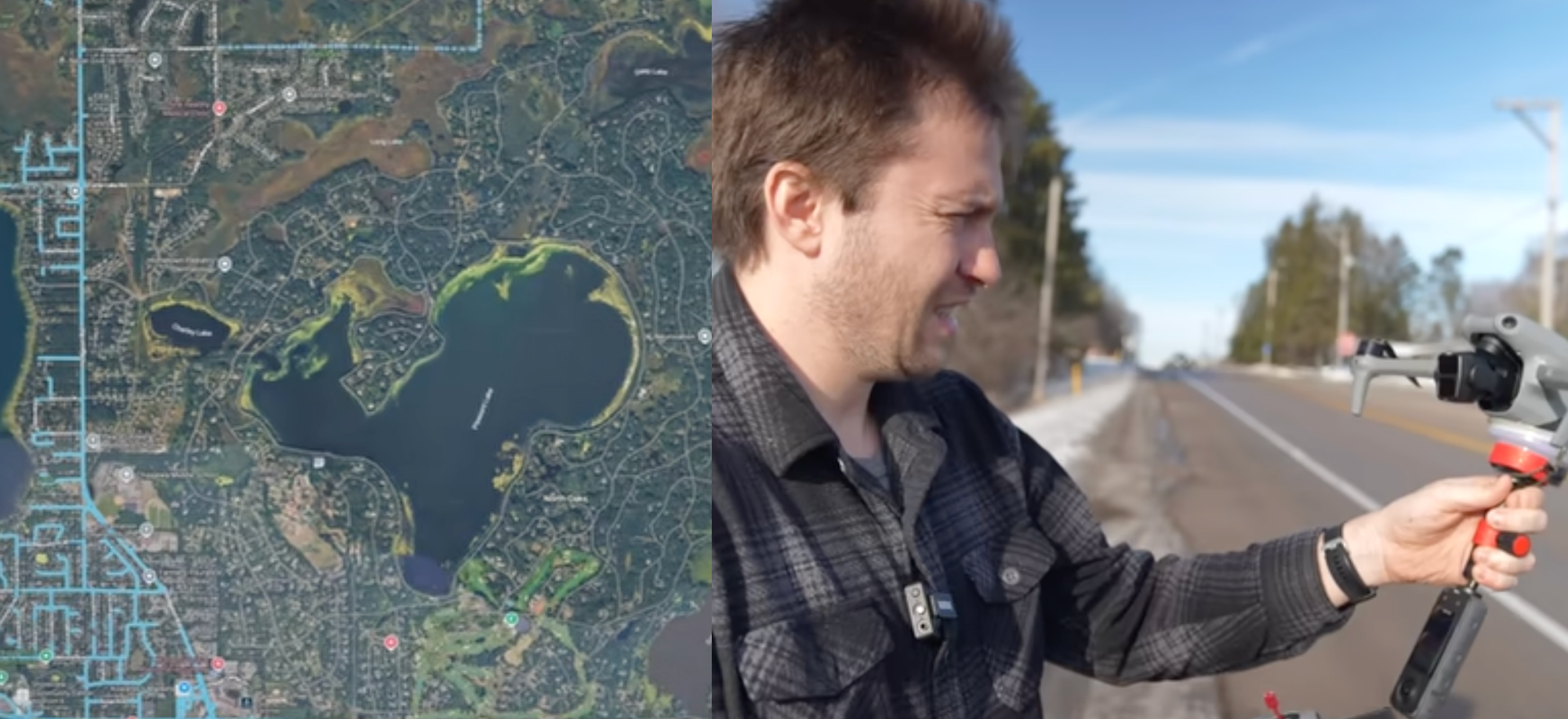 imageミネソタ州ノースオークスは、アメリカ合衆国で唯一Googleマップのストリートビューに存在しない街です。ノースオークスのほど近くで育ったYouTubeドキュメンタリー制作者のクリス・パーは、今年初め、この状況を変えようと試みました。ほんの数日間、彼は文字通りノースオークスを地図上に出現させました。そして、それは再び消え去ったのです。
「ミネソタ州民の間では、ノースオークスは重役やCEOが住む場所として知られています」とパーは404 Mediaに語りました。「有名なところではウォルター・モンデールがノースオークス出身ですし、ユナイテッドヘルスケアやターゲットの重役たちも住んでいます。」
ノースオークスがストリートビュー上でほぼ未マッピングの状態を維持できているのは、この街特有の道路管理方式によるものです。アメリカのほぼすべての都市や町では、土地所有者が自宅前の道路について地方政府に地役権を設定しています(あるいは道路に対して一切の権利を主張しません)。一方、ノースオークスでは、住宅所有者の所有地が道路の中央まで及んでおり、文字通り街の中に「公共」の土地は存在せず、道路はノースオークス住宅所有者協会(NOHOA)によって維持管理されています。情報が非常に少なく、「ほとんどの非公開文書を一般に共有することはできない」と記された協会のウェブサイトには、「市は道路、土地、建物を一切所有していません。市内の50〜60マイルに及ぶ道路は、NOHOAへの地役権に従い、所有地が道路の中心まで及んでいるNOHOA会員によって所有されています」と説明されています。ノースオークスに入る道路には、立ち入り禁止の標識と自動ナンバープレート読取装置が設置されています。
Googleマップの初期には、ノースオークスもストリートビューに掲載されていました。しかし2008年5月、市はGoogleのストリートビュー車が不法侵入したとして訴訟を起こすと通告しました。Googleはストリートビューの画像を削除し、それ以来、ノースオークスはストリートビューから姿を消したままです。
「これは、世間を遠ざけようと考えるお高くとまった人々の問題ではない」と、当時のトーマス・ワトソン市長は2008年にスター・トリビューン紙に語りました。「彼ら(Google)は私有地に入るいかなる許可も得ていなかったのです。」
しかし、Googleマップではユーザー自身が画像をアップロードできます。そこでパーは、実際に現地に行かずにノースオークスをマッピングする方法を模索し始めました。そして、ドローンを使ったマッピングを思いついたのです。
「これは地理的な特異点です」とパーは言いました。「ノースオークスの上空の空域は、地上の所有地とは別のルールで運用されていると気付きました。ドローンで効果的に街をマッピングできると考えたのです。」
パーの言う通りです。国家的な空域は連邦航空局(FAA)によって管理され、「空域」は地上の真上から始まります。これは、一般向けドローンが登場した初期、町が特定区域でのドローン飛行を禁止しようとした際、繰り返し論点となった問題です。
「技術的には、公共の土地からドローンを離陸させれば(登録されたドローンパイロットであれば誰でも可能です)、そのまま真上に飛ばして私有地の上空を飛行できます」とパーは説明しました。彼はノースオークスの境界線のすぐ外側にある「6、7か所の地点」に立ち、ドローンを飛行させました。「ただ車を路肩に停めて、ドローンを飛び立たせ、上空を飛ばしただけです」と彼は付け加えました。
街の境界外からドローンでは到達できない区域もあったため、最終的に彼は、ドローンの飛行を続けるために境界内の公園に行く必要があり、そのためには招待を受ける必要があると判断しました。
「ノースオークスの条例によれば、友人を訪問したり、家の工事をする請負業者であれば街に入れますが、招待されたゲストでなければなりません」とパーは言いました。「私はCraigslistに、誰かに招待してくれるよう頼む投稿をし、非常に多くの反応を得ました。マギーという女性とメッセージのやり取りを始め、彼女が私を招待してくれたので、技術的には公園に行く招待状を得たことになります。」
その後、パーはドローンで撮影した映像をGoogleマップにアップロードしました。輝かしい数日間、ノースオークスはマッピングされました。そして、再び消えてしまったのです。
「それ以来、画像にフラグを立てる人々との戦いを続けています」と彼は語りました。また、ノースオークス住宅所有者協会を代表する法律事務所から手紙も受け取りました。「ビデオを削除するよう求めているわけではありませんが、基本的には『二度と来るな』という内容です。」
パーの実験とドキュメンタリーは、当然ながら、アメリカで誰がプライバシーを享受できるのかという疑問を投げかけています。富裕層の居住区は、マッピングされないようにするための法的および監視インフラを構築しています。一方、私たち一般市民は、隣人や法執行機関によるあらゆる種類の監視の対象となっています。「このような仕組みが成立している唯一の理由は、それが非常に裕福なコミュニティだからです」とパーは言いました。「自分にこれができたことは分かっていますが、自分がこれをするべきなのかどうかは分かりません。それが私が取り組みたかった問いなのです。YouTubeのコメントはかなり極端ですよ。賛否が真っ二つに分かれ、その問いに対してはほぼ50対50です。」
ノースオークスはコメントの依頼に対して返答しませんでした。
原文を表示
imageNorth Oaks, Minnesota is the only city in the United States that is not on Google Maps Street View. YouTube documentarian Chris Parr, who grew up not too far from North Oaks, set out to change that earlier this year. For a brief few days, he literally put North Oaks on the map. And then it was gone again.
“It’s known by Minnesotans as a place where executives and CEOs live,” Parr told 404 Media. “Famously Walter Mondale is from North Oaks, but also like United Healthcare executives and Target executives.”
North Oaks has managed to largely stay unmapped on Street View because of the way the city handles its streets. In almost every city and town in the United States, property owners give an easement to their local government for the roads in front of their homes (or don’t have any claim to the roads at all). In North Oaks, homeowners’ property extends into the middle of the street, meaning there is literally no “public” property in the city, and the roads are maintained by the North Oaks Homeowners’ Association (NOHOA): “the City owns no roads, land, or buildings. The 50-60 miles of roads in the city are owned by the NOHOA members whose property extends to the center of the road subject to easements in favor of NOHOA,” the homeowners association’s website, which has very little information on it and notes that it is “unable to share most private documents with the public.” The roads entering North Oaks have no trespassing signs posted and automated license plate readers.
In the early days of Google Maps, North Oaks was on Street View. But in May, 2008, the city threatened Google with a lawsuit because its Street View cars had trespassed. Google deleted its Street View images and North Oaks hasn’t been on Street View since.
"It's not the hoity-toity folks trying to figure out how to keep the world away," then-Mayor Thomas Watson told the Star Tribune in 2008. "They [Google] really didn't have any authorization to go on private property."
Google Maps allows people to upload their own images, however. And Parr set out to find a way to map North Oaks without actually going there. So he began mapping it with a drone.
“It’s a geographic oddity,” Parr said. “I realized the airspace above North Oaks operates differently than the property on the ground. I thought you could effectively map the city with a drone.”
Parr is right. The national airspace is technically managed by the Federal Aviation Administration, and “airspace” starts directly above the ground, which is something I covered over and over in the early days of consumer drones as towns sought to ban drones in certain areas.
“Technically, if you launch your drone from public property, which anyone can do if you’re a registered drone pilot, you can fly it straight up and above private property,” Parr said. And so Parr stood at “six or seven different spots” directly outside the boundary of North Oaks and flew his drone around. “I just pulled my car over onto the shoulder and popped my drone up and flew it over,” he added.
There were parts of North Oaks that he couldn’t reach by drone from outside the boundaries of the city, so eventually he decided he needed an invite into the city to go to a park within its boundaries to keep flying his drone.
“According to North Oak’s ordinances, you can go like, visit a friend, or if you’re a contractor working on a house, you can go into the city, but you have to be an invited guest,” Parr said. “I made a Craigslist post asking for somebody to invite me and I got an absolute ton of responses. I started texting with this woman named Maggie and she invited me, so technically I had the invite to go to the park.”
Parr then took his drone footage and uploaded it to Google Maps. For a few glorious days, North Oaks was mapped. And then it was gone.
“I’ve since been in a battle with the people who flag the images,” he said. He also got a letter from a law firm representing the North Oaks Homeowners Association. “It’s not asking me to take any of the videos down or anything, but basically they say, ‘Don’t come back.’”
Parr’s experiment and documentary raises questions, of course, about who gets to have privacy in America. A wealthy enclave has set up the legal and surveillance infrastructure to be able to prevent being mapped. The rest of us, meanwhile, are subject to all sorts of surveillance by our neighbors and law enforcement. “The only reason it’s set up this way is because it’s such a wealthy community,” Parr said. “I know that I was able to do this, but I don’t know if I should be able to do this, and that’s kind of the question that I wanted to tackle. The YouTube comments are pretty crazy man. They’re all over the place. They’re very split 50/50 on that question.”
North Oaks did not respond to a request for comment.
同じ出来事を6媒体で確認
同じ出来事を扱う別媒体の記事です。見出しと公開時刻を比較できます。
今日のまとめ
AIデイリーブリーフで今日の重要ニュースをまとめ読み